#! /usr/bin/perl -w
#
# gmtperl-example.pl
#
# J.J.Green 2001, 2004
# This code is in the Public Domain
use Cartog::GMT;
$usage = "usage: perl gmtperl-example.pl <filename>\n";
# get output filename (no fancy getopt() here)
$output = shift @ARGV or die $usage;
# abbreviate some GMT command line options, etc
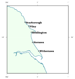
$range = "-R-1.0/1.0/53.3/54.6";
$proj = "-JM3.5i";
$ticks = "-B1/1";
$res = "-Df";
$defs = "gmtperl-example.def";
$common = "$range $proj -P";
# the town data; array populated from a "here" document
# containing data pasted from database output
@towndat = <<TOWNS =~ m/(\S.*\S)/g;
0.0333333 53.7333333 Withernsea
-0.4141667 54.2872222 Scarborough
-0.1666667 53.9 Hornsea
-0.2891667 54.21 Filey
-0.2080556 54.095 Bridlington
TOWNS
# callback function to write out the lat/long values
# from a @towndat like array
# callback function to write out the lat/long values
# from a @towndat like array
sub xycat
{
my ($stream, $lines) = @_;
foreach my $line (@$lines)
{
chomp $line;
my ($lng, $lat) = split ' ', $line;
print $stream "$lng $lat\n";
}
return 1;
}
# callback function to modify lines of towndata to the
# psxy format. The second argument is a reference to an
# array with components ($size, $angle, $font, $align, $lines) where
#
# $size font size in (postscript) points
# $angle angle of rotation
# $font font number or name
# $align alignment
# $lines a reference to an array of lines to be processed
sub xyformat
{
my ($stream, $data) = @_;
# unpack the arguments
my ($size, $angle, $font, $align, $lines) = @$data;
foreach my $line (@$lines)
{
chomp $line;
my ($lng, $lat, $name) = split ' ', $line;
print $stream "$lng $lat $size $angle $font $align $name\n";
}
return 1;
}
# set up the map
$map = new Map;
$map->defaults($defs);
$map->output($output);
$map->verbose(1);
# use the Debian GMT wrapper script
$map->wrapper('GMT');
# get the map's layer set
$layers = $map->layers(new Layers);
# add coast layers ...
$layers->pscoast("$common $res -G240/255/240");
$layers->pscoast("$common $res -W1p/30/120/150");
# town positions, using the xycat callback
$layers->psxy("$common -Sc4p -W3 -G255", \&xycat, \@towndat);
# towns names using the xyformat callback and passing the
# text parameters and raw town data by reference
$layers->pstext("$common -D4p/0p -S5/255",
\&xyformat,
[10, 0, "Bookman-Demi", "LM", \@towndat]);
# add map furniture
$layers->psbasemap("$common $ticks");
# now draw it
$map->draw();